


Munro Bagging

Munro Bagging açıklaması
Munro Bagging is an application that allows you to browse through all of the significant hills in Britain, including the Munros, the Murdos, the Grahams, Marilyns and Corbetts.
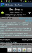
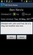
As well as providing information on each hill (useful for walk planning), you can record notes from when you climbed it.
Features:
- Search for hills by name
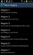
- List hills by name, height or region
- See information on hills' classification, height, prominence, location, summit features and useful Ordnance Survey maps
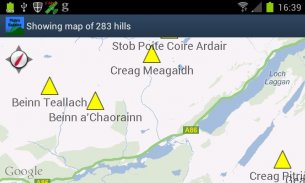
- View hill location on a map, either individually or all together
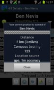
- Get bearing and distance from the phone's current location to the hill summit
- Audio pronunciations of hill names, via the optional Munro Bagging Sounds extension application
Features to come:
- Import/export climb notes to file, to allow migration between phones
- Integration with photo albums
- Social media integration ("share my climb")
Uses data from the Database of British and Irish Hills (<a href="https://www.google.com/url?q=https://www.google.com/url?q%3Dhttp://www.hills-database.co.uk/%26sa%3DD%26usg%3DAFQjCNF5WWSxNsuEG8kmL2Q-f1gsadAJEA&sa=D&usg=AFQjCNHS1qF4GFX0vmksxt-RDOdc7g7A6Q" target="_blank">http://www.hills-database.co.uk/</a>), licensed under Creative Commons 3.0.
Audio clips supplied by and used with kind permission of Comunn na Gàidhlig (CnaG) (<a href="https://www.google.com/url?q=https://www.google.com/url?q%3Dhttp://www.cnag.org.uk/%26sa%3DD%26usg%3DAFQjCNGXmnIk-wTCvGOwlklmmfvgxI20Jw&sa=D&usg=AFQjCNFOeR-ZRMwLFdmOOdZnc0j-Cb6-iA" target="_blank">http://www.cnag.org.uk/</a>)
</div> <div jsname="WJz9Hc" style="display:none">Munro Torbalama Eğer Munros, Murdos, Grahams, Marilyn ve Corbetts dahil olmak üzere İngiltere'de önemli tepeler, tüm göz atmak için sağlayan bir uygulamadır.
Yanı sıra her tepe hakkında bilgi (yürüyüş planlaması için yararlı) sağlamak gibi, bunu tırmandı zaman notlar kaydedebilirsiniz.
Özellikler:
- İsme göre tepeler ara
- Liste adı, yükseklik ya da bölgeye göre tepeler
- Tepeler 'sınıflandırma, boy, önem, yer, zirve özellikleri ve yararlı Ordnance Survey haritaları bilgilere bakın
- Tek tek veya hep birlikte Haritada göster tepe konumu,
- Tepenin zirvesine telefonun geçerli konumundan yatak ve mesafe alın
- İsteğe bağlı Munro Torbalama ile tepe isimleri Ses telaffuzlar, uzatma uygulama Sesler
Gelmek Özellikler:
- Dosyaya İthalat / İhracat tırmanış notları, izin telefonlar arasında göç
- Fotoğraf albümleri ile entegrasyon
- Sosyal medya entegrasyonu ("benim tırmanış paylaşmak")
Creative Commons 3.0 altında lisanslı İngiliz ve İrlanda Hills (<a href="https://www.google.com/url?q=http://www.hills-database.co.uk/&sa=D&usg=AFQjCNF5WWSxNsuEG8kmL2Q-f1gsadAJEA" target="_blank">http://www.hills-database.co.uk/</a>) ve veritabanı verileri kullanır.
Ses klipleri tarafından sağlanan ve Comunn na Gàidhlig (CnaG) (<a href="https://www.google.com/url?q=http://www.cnag.org.uk/&sa=D&usg=AFQjCNGXmnIk-wTCvGOwlklmmfvgxI20Jw" target="_blank">http://www.cnag.org.uk/</a>) tür izni ile kullanılır</div> <div class="show-more-end">


